You are using an out of date browser. It may not display this or other websites correctly.
You should upgrade or use an alternative browser.
You should upgrade or use an alternative browser.
Apple Issues Statement on Maps Issues
- Thread starter Maura
- Start date
evohicks
iPF Noob
That's a bit harsh, what's this all about?Good karma said:not cheats like andriod who prefer to take the easy way out by cheating.
evohicks
iPF Noob
pinkbux28 said:I just updated my ipad 3 from ios 5 to ios 6 and it blurred my map, the old functions of the map which i like most is gone. Now i'm using google earth. What happened to the old map apps of ipad? It's one of the reason why I bought ipad.
Read from the start of the thread, and many like it, Apple are running their own map software now, hopefully google will come up with an app of their own soon.
G
Grytpype
Guest
Christmas which year – 2020?... by christmas i am hoping a lot of the shambles now will be ironed out
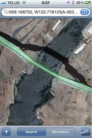
So after listening to all of the moaning about Apple Maps over the last few days, I thought I'd take a look at what Google made of one of Apple's worst bits, namely the Hoover Dam Bypass. The Apple Map clearly shows the road plunging down an almost vertical drop, which an amusement park would consider too terrifying. It would take a vehicle with about as much power as, say, a Space Shuttle to ascend the road as Apple shows it. So how does Google compare? Well, see for yourselves.

The same view, the same terrifying descent, the same impossible ascent, the same image. Only difference is that you can make Apple's version look worse by careful manipulation of the 3D image.
Google did manage to get the Eiffel Tower right. Apple tipped it over somehow.
Sent from my iPhone using iPF
KevinJS said:So after listening to all of the moaning about Apple Maps over the last few days, I thought I'd take a look at what Google made of one of Apple's worst bits, namely the Hoover Dam Bypass. The Apple Map clearly shows the road plunging down an almost vertical drop, which an amusement park would consider too terrifying. It would take a vehicle with about as much power as, say, a Space Shuttle to ascend the road as Apple shows it. So how does Google compare? Well, see for yourselves.
<img src="http://www.ipadforums.net/attachment.php?attachmentid=26089"/>
The same view, the same terrifying descent, the same impossible ascent, the same image. Only difference is that you can make Apple's version look worse by careful manipulation of the 3D image.
Google did manage to get the Eiffel Tower right. Apple tipped it over somehow.
Sent from my iPhone using iPF
But Apple doesn't know that Paddington International Station, probably the biggest station in London, exists and when I searched for Paddington, it took me to Brisbane in Australia.
pyewacket
iPF Noob
So after listening to all of the moaning about Apple Maps over the last few days, I thought I'd take a look at what Google made of one of Apple's worst bits, namely the Hoover Dam Bypass. The Apple Map clearly shows the road plunging down an almost vertical drop, which an amusement park would consider too terrifying. It would take a vehicle with about as much power as, say, a Space Shuttle to ascend the road as Apple shows it. So how does Google compare? Well, see for yourselves.
View attachment 26089
The same view, the same terrifying descent, the same impossible ascent, the same image. Only difference is that you can make Apple's version look worse by careful manipulation of the 3D image.
Google did manage to get the Eiffel Tower right. Apple tipped it over somehow.
Sent from my iPhone using iPF
Looking at that closely..and the small "squares" in the picture..I am sure the black "road" is in fact a shadow from the bridge..
....tho I have been known to be wrong....
pyewacket said:Looking at that closely..and the small "squares" in the picture..I am sure the black "road" is in fact a shadow from the bridge..
....tho I have been known to be wrong....
The black artifact is a shadow. The depiction of the road itself is in error on both systems.
skallal
iPF Novice
I don't know if it this has been mentioned in this thread yet, but there is a app in the store called "Live Street View", that does just what the title suggests, it gives you street view, and direct from Google maps. The downside is that the street view is not full-screen, but rather a little pop-up window. And I don't know if it includes navigation. So far this is the only workaround I've seen for the missing street view functionality.
There is a free version and a $0.99 version in the App Store.
There is a free version and a $0.99 version in the App Store.
G
Grytpype
Guest
Don't do it.
G
Grytpype
Guest
See my sigline (below). The Apple Maps app is a disaster which will take them ages to fix.
Similar threads
- Replies
- 23
- Views
- 10K
