What's new
Apple iPad Forum 🍎

Welcome to the Apple iPad Forum, your one stop source for all things iPad. Register a free account today to become a member! Once signed in, you'll be able to participate on this site by adding your own topics and posts, as well as connect with other members through your own private inbox!

How to import Google Earth files

Wakawaka

iPF Noob
Joined
Sep 18, 2010
Messages
550
Reaction score
2
Location
Colorado
Anyone know how to import Google Earth files into the iPads google Earth?

I'm starting to setup and use my iPad more and more for work to show it can be a great tool for the work place IN the field (and at the office). But I'm in need to be able to use some simple tools. I have roughly about a month or two before I'm out to there to try it out so a little time to set things up and play around.

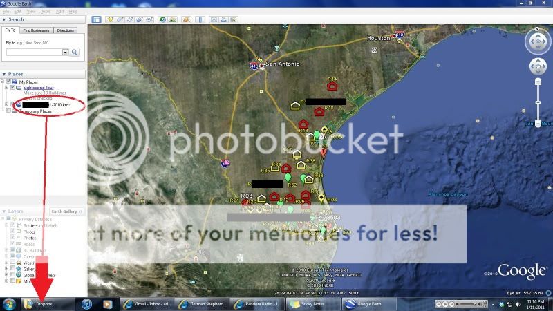
My boss has sent me a .KMZ file (stores locations and data about "sites" - See photo below). I downloaded the file and was able to click and drag into the Google Earth program on the Windows 7 PC. Pulled up each site with detailed information.

I then saved that file into DropBox. The iPad was able to locate the file, and says "Can not display" or something along those lines. However if exporting to an APP, it does give me the option for Google Earth. If tapped, it will open Google Earth. However none of the data opens up.

This is a file I'll be using a bit, and prefer to use it on the iPad.


Ideas??:confused:

Texas.jpg
 
Last edited:
I wish I could help.
Here is MY problem.
Here in Israel I can't access it. It is one of the applications not provided here .
 
Sorry Waka I have no idea other than use Splashtop.
You really are out on your own at the cutting edge of technology on this one :(
 
I figured it out.. first major problem was IE8.

You need to go to maps.google.com and if you don't have an account create one.

Then upload the .KMZ file under your maps. (My issue was IE8 kept giving me an error saying misinformed and illigal or something like that in a pop up window..)

Use Safari or FireFox and upload your .KMZ file. This will now save the file in your MAPS account.

As stated above, on google earth app on the iPad, go to layers, click on MY MAPS, and you should see all your uploaded maps now.

Worked perfectly for me! I got all 60 sites displayed with all saved information on each site. This will make my job so so much easier!
 
Use a KML file

You must use a KML as KMZs don't appear to work. You can easily convert the KMZ to KML by opening the KMZ in Google Earth. Right click on the layer and click "Save Place As...". Then just save the layer as a KML (vs KMZ. KMZ is just compressed).

Upload the KML file to the web (I uploaded it via FTP to my web server). Navigate directly to the kml file using the Safari App (internet app) and click "Open in Google Earth." This will open Google Earth to the extent of the kml layer. You can then use the find location button of Google Earth (bottom left) to show data and know where you currently are. This will enable you to quickly visualize data in the field with the phone's built in GPS. Much more reliable and faster than using the W3C's geolocation API and Google Maps.

It worked for me with a 1MB file on my iPhone. I've not tested it yet on an iPad, but imagine it should work.

Copy this link to test page: vtid.us /test /zetest.kml
 
Worked great for me

I figured it out.. first major problem was IE8.

You need to go to maps.google.com and if you don't have an account create one.

Then upload the .KMZ file under your maps. (My issue was IE8 kept giving me an error saying misinformed and illigal or something like that in a pop up window..)

Use Safari or FireFox and upload your .KMZ file. This will now save the file in your MAPS account.

As stated above, on google earth app on the iPad, go to layers, click on MY MAPS, and you should see all your uploaded maps now.

Worked perfectly for me! I got all 60 sites displayed with all saved information on each site. This will make my job so so much easier!

I was having the same issue - we've had issues with municipalities/cities that we've been working for who couldn't be bothered to coordinate our database with GIS - now we can skip that whole issue by creating layers in Google Earth and uploading them to our iPads - access the database for site information and data entry in the field, and view real-time site access and locations via polygons on Google Earth on the iPad. Thanks for figuring this out for me - I was just starting to wrestle with the problem, and you saved me lots of trial and error! I uploaded my layer using Google Chrome, so that works as well.
 
zesandler said:
You must use a KML as KMZs don't appear to work. You can easily convert the KMZ to KML by opening the KMZ in Google Earth. Right click on the layer and click "Save Place As...". Then just save the layer as a KML (vs KMZ. KMZ is just compressed).

Upload the KML file to the web (I uploaded it via FTP to my web server). Navigate directly to the kml file using the Safari App (internet app) and click "Open in Google Earth." This will open Google Earth to the extent of the kml layer. You can then use the find location button of Google Earth (bottom left) to show data and know where you currently are. This will enable you to quickly visualize data in the field with the phone's built in GPS. Much more reliable and faster than using the W3C's geolocation API and Google Maps.

It worked for me with a 1MB file on my iPhone. I've not tested it yet on an iPad, but imagine it should work.

Copy this link to test page: vtid.us /test /zetest.kml

Hi there, I have a range of posts, locational markers across the Australian rail network. If I follow your instructions above will I be able to get these posts onto google earth on my iPad
 
Yep. It should work as described above. Let me know if you experience any issues and we can figure out how to make it work.
 
mjtyler said:
Hi there, I have a range of posts, locational markers across the Australian rail network. If I follow your instructions above will I be able to get these posts onto google earth on my iPad

I am not sure what it means to upload to the web. Do I do this from iPad or computer?
 
mjtyler said:
I am not sure what it means to upload to the web. Do I do this from iPad or computer?

So what I did was this:
I open GE and saved the Z files a s L files and saved them on my work desktop.
I emailed those to my iPad
I went to open them in GE but the markers don't come up

Any ideas?
Thanks
 
Yep. It should work as described above. Let me know if you experience any issues and we can figure out how to make it work.

Hi there, I have tried your method by uploading a KML file to my webspace and emailing the link to a friend so he can open it in Safari on his 4G phone. It doesn't give him an option to open it in Google Earth, instead it just opens the link and gives him source code. Is there any options you need to set on the phone or Safari to allow the option to open the file in Google Earth?

Thanks very much.
 
First: Does your friend have Google Earth installed on his/her phone?

If you email the kml as an attachment vs. navigating directly to the kml file uploaded to the web (use some sort of FTP to accomplish this), iPhone 4 will first display the kml source code. To open with Google Earth to click on the top right on the "download" button (looks like the arrow in a folder deal). This will provide you three options: Open in Google Earth, Print, or Cancel.

Click "Open in Google Earth" and Google Earth should open to the extent of the kml. Use the find location icon (bottom left of the iphone) to find your current location.

Hope this helps. Test this if you want to see what I'm working with: vtid.us/test/zetest.kml

Contact me if you need further assistance: zach at vtid . us
 
Last edited:

Most reactions

Latest posts

Back
Top